MapSimple
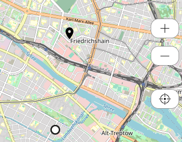
A map showing the users locationm, markers, and a popup that appears when you tap on them.
Data for multiple markers must be loaded using DataLoaderMulti (or if you only want to show only a single marker, through DataLoaderSingle).
See the Data Loading tutorial for an example of setting up a simple map.
See MapViewButton for an interface that provides filters and layers.
Developer docs
Props
| Prop | Type | Default | Description |
|---|---|---|---|
| clickTrigger* | |||
| mapBoxGLStyle* | |||
| tileLayer* | |||
| showPopups* | |||
| showControls* | |||
| height* | |||
| defaultLocation* | |||
| hideOnMapColumn* | |||
| markerTitleColumn* | |||
| markerLabelColumn* | |||
| customIconColumn* | |||
| secondaryPositionProperty* | |||
| markerPositionsColumn* | |||
| markerCheckedIconAsset* | |||
| markerIconAsset* | |||
| checkedProperty | string |
"checked" |
|
| defaultZoom | number |
13 |
|
| permissionNotification | string |
"Die App hat keine Erlaubnis, ihre Position festzustellen. Unter Start > Einstellungen > FAQ finden Sie eine Anleitung, um die Erlaubnis für Ihr Gerät zu erteilen." |
|
| enableGeolocationHint | string |
"Bitte aktivieren Sie ihren Standort." |
|
| mapId | string |
"map" |
|
| nearestElementMode | boolean |
false |
|
| inline | boolean |
false |
|
| disableControls | boolean |
false |
|
| singleElementContext | boolean |
false |
|
| closeButtonLabel | string |
"Schließen" |
Slots
| Name | Default | Props | Fallback |
|---|---|---|---|
| button | No | ||
| popup | No |
Source
see source code
<script>

  import { onMount, setContext, getContext, onDestroy } from 'svelte'
  import { get, writable } from 'svelte/store'
  import { fly } from 'svelte/transition';

  import { InterkitClient, util } from '../'
  import { executeTrigger } from '../actions'
  import { getShowDummyDataStore } from './dummyDataHelpers.js'

  import Button from './Button.svelte'
  import ButtonBar from './ButtonBar.svelte';
  import Icon from './Icon.svelte'
  import MapRenderer from './MapRenderer.svelte'
  import ContextProvider from './ContextProvider.svelte';

  export let markerIconAsset; // default asset to use
  export let markerCheckedIconAsset; // checked asset
  export let markerPositionsColumn; // where the markers are
  export let secondaryPositionProperty; // an optional elementProperty that gives an element a user specific position
  export let customIconColumn; // a custom mediafile as icon for each element
  export let markerLabelColumn; // a short custom string for the marker (eg "01")
  export let markerTitleColumn; // a short custom string to appear above the marker, outside the bubble (eg "Foo Station")
  export let hideOnMapColumn; // option on elements to hide on map
  export let checkedProperty = "checked" // what property to use for the checkmark

  export let defaultLocation; // where to center the map [lat, lng]
  export let defaultZoom = 13; // default zoom level for the map
  export let permissionNotification = "Die App hat keine Erlaubnis, ihre Position festzustellen. Unter Start > Einstellungen > FAQ finden Sie eine Anleitung, um die Erlaubnis für Ihr Gerät zu erteilen.";
  export let enableGeolocationHint = "Bitte aktivieren Sie ihren Standort."
  export let height; // height of the container
  export let showControls; // true if we should show controls
  export let showPopups; // true if we should show popup on marker tap
  export let mapId = "map"; // id of the map
  export let nearestElementMode = false; // mode to show only the nearest element
  export let inline = false;
  export let disableControls = false;
  export let singleElementContext = false; // mode to retrieve element from context and show just that

  export let tileLayer // simple tileLayer, "https://tile.openstreetmap.org/{z}/{x}/{y}.png";
  let activeTileLayer = tileLayer // this can be changed through MapViewButton

  export let mapBoxGLStyle // mapboxGL style, probably a URL like https://api.maptiler.com/maps/1234uuid/style.json?key=f0o. If null-ish or "interkit", default stadiamaps (non-mapboxGL) will be used.
  let activeGLStyle = mapBoxGLStyle // this can be changed through MapViewButton

  export let closeButtonLabel = "Schließen"
  export let clickTrigger;

  // set defaultJson if theming is on
  const themeStyleUrl = "theme/maptiler/style.json"
  let defaultGLStyle = false
  const config = get(InterkitClient.config)
  console.log("MapRenderer config", config)
  if (config && config.INTERKIT_APP_LOAD_THEME) {
    // check if themeStyleUrl returns a json
    fetch(themeStyleUrl)
      .then(response => response.json())
      .then(data => {
        console.log("MapRenderer theme style.json found")
        defaultGLStyle = themeStyleUrl
      })
      .catch(e => {
        console.error(themeStyleUrl + " not a valid json", e)
      })
  }

  // for new iOS only at this moment
  const deviceorientationRequestPermission = () => {
    if (typeof DeviceMotionEvent.requestPermission === 'function') {
      console.log('DME reqPerm')
      DeviceMotionEvent.requestPermission()
        .then(permState => {
          console.log('DME reqPerm then', permState)
          if (permState === 'granted') {
            console.log('DMQ reqPerm granted')
            // the event listener will pick up deviceorientation events now
          }
        })
        .catch(e => {
          console.error('permReq error', e)
        })
    }
  }

  let columnMap = {
    customIconColumn,
    markerLabelColumn,
    markerTitleColumn,
    hideOnMapColumn,
    markerPositionsColumn
  }

  const elementProperties = InterkitClient.getGlobalStore("elementProperties")
  const mapFocus = InterkitClient.getGlobalStore("mapFocus")

  // check if secondaryPositionProperty should be used for mapFocus
  let mapFocusProcessed
  const processMapFocus = (value) => {
    let processed = value;
    if(value && value?.key && secondaryPositionProperty
      && $elementProperties?.[value?.key]?.[secondaryPositionProperty]) {
        processed = $elementProperties?.[value?.key]?.[secondaryPositionProperty]
      }
    selectedElement = value
    return processed;
  }
  $: mapFocusProcessed = processMapFocus($mapFocus)

  const userPositionStore = InterkitClient.getGlobalStore("userPosition");

  let markerObjects;
  let markerData;
  let selectedElement;
  let nearestElement;
  let singleElement;

  let elementsContext = getContext("elements");
  let elements = elementsContext?.elements;
  console.log("MapSimple, got elements from context", elements)

  let unsubElements; // unsubscribe method to this store
  let markerObjs; // where we store the objects

  // retrieve row from qr scanner and convert to object with the columns specified in map
  let qrContext = getContext("qr-scanner")
  if(qrContext?.targetElementObj) {
    singleElement = util.rowToObject(qrContext.targetElementObj.row, columnMap)
    console.log("singleElement", singleElement, columnMap)
  }

  // check if we should show only a single element specified through context
  const elementContext = getContext("element")
  $: {
    if(singleElementContext) {
      if($elementContext) {
        singleElement = util.rowToObject($elementContext, columnMap)
        console.log("singleElement", singleElement)
        updateMarkerData();
      }
    }
  }

  if(!elements && !singleElement) console.warn("Warning: MapSimple needs elements or QRScanner context to show markers");

  // setup dummy data
  function getRandomInRange(from, to, fixed) {
    return (Math.random() * (to - from) + from).toFixed(fixed) * 1;
    // .toFixed() returns string, so ' * 1' is a trick to convert to number
  }
  const showDummyData = getShowDummyDataStore()
  const dummyLocations = [
    ...Array(10).fill(null).map(_ => [getRandomInRange(-90, 90, 3), getRandomInRange(-180, 180, 3)]),
    [52.52083594391814, 13.409404500259926]
  ]
  const dummyData = dummyLocations
    .map(([lat, lng], k) => ({
      key: `${k}`,
      row: {
        key: `${k}`,
        values: {
          position: { lat, lng },
          markerTitle: `markerTitle ${k}`
        }
      }
    }))

  /*
  const dummyData = [
    ...Array(10).keys()].map((k) => {return {key: `${k}`, row: {key: `${k}`, values: {
      position: {
        lat: getRandomInRange(-90, 90, 3),
        lng: getRandomInRange(-180, 180, 3)
      },
      markerTitle: "markerTitle"
    }
  }}})
  */
  const dummyDataStore = writable(dummyData)
  if($showDummyData) {
    elements = dummyDataStore
    console.log("set elements to dummyData")
  }
  if($showDummyData) {
    columnMap.markerPositionsColumn = "elements/position"
    columnMap.markerTitleColumn = "elements/markerTitle"
  }
  // more dummy Data set in MapRenderer/createIconDivHTML

  // set up subscription
  const initDataSubs = async () => {
    if(elements) {
      // convert elements to objects with the columns we need
      unsubElements = elements.subscribe((data)=>{
        console.log("map elements data", data)
        markerObjs = data.map(e => util.rowToObject(e.row, columnMap));
        console.log("map elements markerObj", markerObjs)
        updateMarkerData();
      })
    }
  }

  const distanceSort = (a, b) => {
    return util.getDistance(a.markerPositionsColumn, $userPositionStore) - util.getDistance(b.markerPositionsColumn, $userPositionStore)
  }

  // a store for active map views changed in MapViewButton
  const mapViewState = InterkitClient.getGlobalStore("mapViewState-" + mapId)

  // update activeTileLayer and activeGLStyle if map layer changed
  const updateTileLayer = (layer) => {
    if(layer) {
      activeTileLayer = layer?.tilesUrlColumn
      activeGLStyle = layer?.mapBoxGLStyleColumn
    } else {
      activeTileLayer = tileLayer
      activeGLStyle = mapBoxGLStyle || defaultGLStyle
    }
  }
  $: {
    defaultGLStyle // trigger updateTileLayer when defaultGLStyle is set
    updateTileLayer($mapViewState?.activeLayers?.[0])
  }

  $: {
    selectedElement;
    $userPositionStore;
    $mapViewState;
    updateMarkerData();
  }

  // preprocess data for marker creation in map renderer
  const updateMarkerData = async () => {

    if(!markerObjs) {
      markerData = [];
      return
    }

    // start with the full set of data
    let selectedData = [...markerObjs];

    // filter data according to active map views
    const filterViews = $mapViewState?.activeFilters || []
    const layerViews = $mapViewState?.activeLayers?.filter(v => v.typeColumn == "layer+filter") || []
    const activeViews = filterViews.concat(layerViews)

    if(activeViews.length && $mapViewState?.markerCategoryColumn) {

      // get the category column on the data row
      const markerCategoryColumn = $mapViewState?.markerCategoryColumn

      // get the keys of the active views
      const activeViewKeys = activeViews?.map(e => e.key)

      let filteredData = []
      // iterate over data and check if it references an active view
      for(let e of selectedData) {
        const referencedViewKeys = e?.row?.values?.[util.colKey(markerCategoryColumn)]?.rowKeys
        if(referencedViewKeys) {
          if(referencedViewKeys.some(k => activeViewKeys.includes(k))) {
            filteredData.push(e)
          }
        }
      }
      selectedData = filteredData
    }

    // if singleElement mode is set, use only that
    if(singleElementContext && singleElement) {
      //console.log("updateMarkerData, using single Element", singleElement)
      selectedData = [singleElement]
    }

    // find nearest element
    if($userPositionStore) {
      let markerObjs_sorted = [...selectedData].filter(r => r.markerPositionsColumn).sort(distanceSort)
      if(markerObjs_sorted.length) {
        nearestElement = markerObjs_sorted[0]
        // if nearestElementMode is set and we have a position, show only nearest element
        if(nearestElementMode) {
          selectedData = [nearestElement]
        }
      }
    }

    // prepare data for marker production
    markerData = selectedData.map(r=> {return {
      location: (secondaryPositionProperty && $elementProperties?.[r.key]?.[secondaryPositionProperty]) ?
                  $elementProperties?.[r.key]?.[secondaryPositionProperty]
                :
                (
                  (r.markerPositionsColumn?.lat && r.markerPositionsColumn?.lng) ?
                  r.markerPositionsColumn : undefined
                ),
      checked: $elementProperties?.[r.key]?.[checkedProperty] ? true : false,
      selected: selectedElement?.key == r.key ? true : false,
      element: r
    }})

    //console.log("updateMarkerData", markerData, mapId, $elementProperties)
  }

  const markerClick = async (e) => {
    //console.log("marker clicked", e.target?.payload);

    if(showPopups) {
      selectedElement = {
        ...e.target?.payload?.elementRow,
        onPlay: () => {selectedElement = null}
      }
    }
  }

  const mapClick = () => {
    selectedElement = null;
  }

  onMount(async ()=>{
    await initDataSubs();
    deviceorientationRequestPermission()
  })

  onDestroy(()=>{
    if(unsubElements)
      unsubElements()
  })

  // set context for buttons in buttons slot
  const buttonPayloadStore = writable(null)
  setContext("buttonBar", {
    buttonPayload: buttonPayloadStore
  });

  // update store whenever it changes
  $: buttonPayloadStore.set(selectedElement ? selectedElement : nearestElement?.row)

  const containerClick = () => {
    deviceorientationRequestPermission()
    if(clickTrigger) {
      executeTrigger(clickTrigger)
    }
  }


</script>

  <!-- svelte-ignore a11y-click-events-have-key-events -->
  <div
    class="MapSimple map-component-container"
    on:click={containerClick}
    class:inline="{inline}"
    class:MapSimple--inline="{inline}"
    >

    {#if selectedElement && $$slots.popup}
      <div class="MapSimple__MarkerPopup marker_popup"
        class:active={selectedElement ? true : false}
        class:MapSimple__MarkerPopup--active={selectedElement ? true : false}
        in:fly="{{ y: 300, duration: 100, opacity: 1 }}"
      >
        <div class="MapSimple__MarkerPopupClose marker_popup_close">
          <Button type="secondary" on:click={mapClick} dummyNoText>
            <Icon type="Thin-Close"/>
            <span>{closeButtonLabel}</span>
          </Button>
        </div>
        <div class="MapSimple__MarkerPopupBackground marker_popup_background">
          {#if selectedElement}
            <ContextProvider
              name="element"
              value={selectedElement}
            >
              <slot name="popup"></slot>
            </ContextProvider>
          {/if}
        </div>
      </div>
    {/if}

    <MapRenderer
      {defaultLocation}
      {defaultZoom}
      {height}
      {showControls}
      {mapId}
      {markerData}
      {markerClick}
      {mapClick}
      {nearestElementMode}
      {nearestElement}
      {singleElement}
      {disableControls}
      tileLayer={activeTileLayer}
      mapBoxGLStyle={activeGLStyle}
      mapFocus={mapFocusProcessed}
      {permissionNotification}
      {enableGeolocationHint}
    />

    {#if $$slots.button}
      <div class="MapSimple__Buttons button-container">
        <ButtonBar hideHelpText>
          <slot name="button"></slot>
        </ButtonBar>
      </div>
    {/if}


  </div>

<style>

  .map-component-container {
    height: 100%;
    position: relative;
  }

  .map-component-container.inline {
    position: relative;
    overflow: hidden;
    height: auto;
    display: flex;
    flex-direction: row;
    min-width: 2.5rem;
    /* FIXME? doesn't exist any more
    font-size: var(--font-size-regular);
    */
  }

  /* need to be very cautious for iOS */
  .map-component-container.inline,
  .map-component-container.inline :global(.Map__Container),
  .map-component-container.inline :global(.map) {
    border-radius: var(--border-radius);
    box-shadow: var(--box-shadow);
  }

  :global(.marker-content-label) {
    font: var(--font-caption-bold);
    letter-spacing: var(--letter-spacing-caption-bold);
  }

  :global(div.marker-container.selected) {
    background-color: var(--color-background-highlight);
  }

  :global(div.marker-container.selected img) {
    filter: grayscale(1);
  }

  .marker_popup {
    position: absolute;
    bottom: calc(var(--outset-y) * 0.5rem);
    padding-left: calc(var(--outset-x) * 0.5rem);
    padding-right: calc(var(--outset-x) * 0.5rem);
    z-index: 2000;
    display: none;
    width: 100%;
    box-sizing: border-box;
  }

  .marker_popup_close {
    position: absolute;
    top: calc(-2.5rem - var(--outset-y) * 0.5rem);
    z-index: 10;
  }

  .marker_popup_background {
    position: relative;
    /*background-color: var(--color-background);
    border-radius: var(--border-radius);
    box-shadow: var(--box-shadow);*/
    overflow: hidden;
  }

  .marker_popup.active {
    display: block;
  }

  .button-container {
    position: absolute;
    z-index: 1000;
    bottom: calc(var(--outset-y) * 0.5rem);
    left: calc(var(--outset-x) * 0.5rem);
    right: calc(var(--outset-x) * 0.5rem);
  }

  :global(.Map__Button__Bar .Button) {
    margin-right: calc(var(--outset-x) * 0.5rem);
  }

</style>